Republic of the Philippines
SUPREME COURT
Manila
EN BANC
G.R. No. L-22266 December 29, 1924
THE DIRECTOR OF LANDS, petitioner,
vs.
JOSE INSA, claimant-appellant, and ARSENIA ENRIQUEZ, claimant-appellee.
Jesus Ocampo and Salvador Franco for appellant.
Jose Martinez de San Agustin for appellee.
OSTRAND, J.:
The question involved in the present case is one of two partly overlapping Torrens titles and is before this court upon appeal from a decision of the Court of First Instance in a cadastral registration case adjudging the land to the appellee Arsenia Enriquez.
The title of the appellant Jose Insa is deraigned from one Severino Lerma who, by a decree of the Court of Land Registration dated January 3, 1905, obtained an original certificate of title to the land in dispute. The appellee Arsenia Enriquez claims title under a transfer certificate of title from Prisca de los Reyes and sisters, who held the original certificate of title under a decree dated December 19, 1905. (See sketches figures Nos. 1 and 2.)
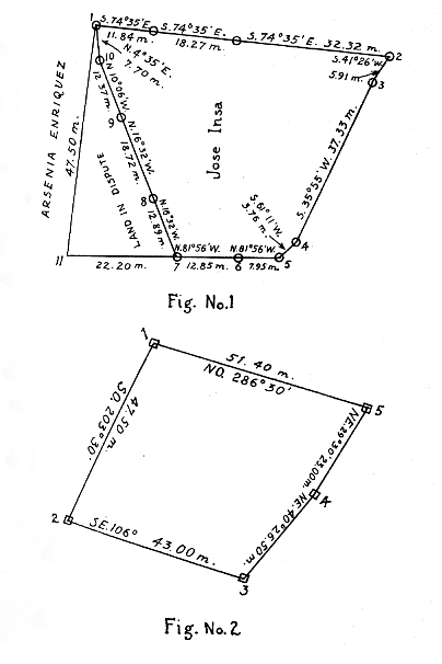
The situation of the land in question may be best understood by a reference to the sketch, fig. 1. The portion lying within the points 1, 2, 3, 4, 5, 6, 7, 8, 9 and 10 of the sketch is high land and the undisputed property of the appellant Insa. The triangular portion lying within the points 1, 10, 9, 8, 7 and 11 is in dispute and is low grass land. The adjoining land to the west of the line 1-11 and to the south of the line 7-11 in the undisputed property of the appellee Enriquez and is low land of the same general character as the disputed portion. Points Nos. 1, 2, 5 and 7 are marked with very old monuments of adobe stone and points Nos. 9 and 10 are marked with old Bureau of Lands monuments probably placed there at the time of the land registration surveys in the year 1904. Most of the other points are marked with new Bureau of Lands monuments. There is no monument of any kind at point No. 11. The line 1-10-9-8-7 is also indicated in the field by a continuous row of heavy bamboo along the entire length of the line.
As already stated, the disputed portion is covered by the certificates of title of both parties. As the decree upon which the appellant's title is founded is older than that of the appellee, the former would, under ordinary circumstances, prevail (Legarda and Prieto vs. Saleeby, 31 Phil., 590) and if the plans from which the land description in the appellant's certificate of title were taken correctly reflected the surveys made for the purpose of the registration we should unhesitatingly reverse the judgment appealed from, irrespective of the consequences to the parties.
But here it is conclusively shown not only by undisputed testimony but also by the plans themselves that the western line shown on the Lerma plan is not the line surveyed and monumented, but simply an imaginary line which has crept into the plan through a mistake of the draftsman in interpreting the field notes of the surveyor.
This clearly appears from sketch fig. 2, a copy of the Lerma plan from which the land described in the appellant's certificate of title is taken. The diminutive squares at corners 1, 2, 3 and 5 represent adobe monuments corresponding to the monuments at points 1, 7, 5 and 2 of sketch fig. 1. In making the survey the surveyor evidently used an Azimuth Compass and began his survey at point 1. In sighting from that point to the monument on the SW. corner of the land, the reading of the compass would be approximately SE. 163º 30' instead of SW 203º 30' as appearing on the plan. The method employed by the surveyor in indicating the courses of the lines was practically unknown in this country at that time and errors in drafting might therefore readily occur.
The error was not discovered until the cadastral survey was made some sixteen years later. In the meantime the appellee occupied the land now in dispute and neither the appellant nor his predecessors in interest laid any claim to it; evidently the thought did not occur to them that the land was included in their certificate of title.
It is also to be observed that in the first few years after the enactment of the Land Registration Act the plans submitted to the Court of Land Registration were usually grossly inaccurate. In the present case the plan we have discussed has an error of closure of 1:119, which shows the existence of such large discrepancies in the courses of the various lines of the plan that it, in any event, would be impossible to determine the exact limits of the land from the plan itself. That the plan on which the description of the land in the certificate of title of the appellee is taken is even more inaccurate does not, of course, improve matters.
The court has therefore somewhat reluctantly arrived at the conclusion that the judgment appealed from must be affirmed. The evidence that the Lerma plan does not show the true lines of the survey upon which it is based and that the error in question lies in the drafting of the plan is conclusive. This is established by the undisputed testimony of persons who were present at the time the survey was made and by the fact that the surveyor very evidently took the adobe monument at point 7 fig. 1 as the southwestern corner of the land; it is further shown by the bamboo hedges surrounding the land and by the monuments existing thereon previously to the survey; and, finally, it is also indicated by the continuous and open occupation of the now disputed portion by the appellee and her predecessors for over sixteen years subsequent to the entry of the decree of registration, without and adverse claim on the part of the appellant.lawphil.net
The survey as actually made must prevail over an erroneous plan where the variance between the two is conclusively established by the evidence and the true boundary lines followed by the surveyor can be definitely ascertained.
The judgment appealed from is affirmed, without costs. So ordered.
Johnson, Street, Malcolm, Avanceña, Villamor, Johns, and Romualdez, JJ., concur.
The Lawphil Project - Arellano Law Foundation


