Republic of the Philippines
SUPREME COURT
Manila
EN BANC
G.R. No. L-10129 February 2, 1916
CLARA TAMBUNTING, petitioner-appellant,
vs.
EDILBERTO SANTOS, objector-appellee.
Haussermman, Cohn and Fisher for appellant.
No appearance for appellee.
MORELAND, J.:
This is a proceeding in the Court of Land Registration to register title to the property described in the application. Edilberto Santos opposed registration on the ground that the land described in the application included lots 3 and 4 as shown on the official plan attached to the petition, which he claims belong to him. The city of Manila also appeared as a respondent, opposing the registration of lots 2 and 3 of said plan, but during the trial it became assured of the groundlessness of its claim and withdrew its opposition.
The Court of Land Registration decided the question in dispute in favor of the respondent Santos and excluded from the decree of registration that portion of the land which he claimed in his answer. From that judgment this appeal is taken.
From the evidence it appears that the original owner of the land described in the application was one Macario de la Cruz, who conveyed in to Gregorio Roman y Gamazo on June 10, 1879, who obtained a possessory information therefor which was registered in the old registry of property of the city of Manila on March 23, 1895. Gregorio Roman afterward conveyed the property to Catalino Boncan y Yap and the latter sold it to Ildefonso Tambunting y Cosiam on August 25, 1902. The land in question came into the hands of the present applicant, through the said Ildefonso Tambunting.
The description of the land is as follows:
An unnumbered building lot located at a point where it faces the alley called Marti, in the barrio of Tutuban, of the district of Tondo, in the city of Manila, within the limits of the registry of property for the northern district. Bounded on the right as you enter by a unnumbered lot belonging to Macaria Lopez; on the left by an unnumbered lot belonging to Apolinaria Santos; and on the rear by a zacate field belonging to Felipe Zamora; having a total area of 445.50 square meters.
The ownership of the land described in the application is unquestioned. The only dispute arises from the location of the boundary line between these lands and those of respondent. The applicant claims that the division line should run from point 1, marked by a stone monument, of lot No. 4 to the corner marked 4 of the same lot, and from this point to the point marked 2 on lot No. 3, which is the line of what was called in the old description above quoted "an alley,' but which is now known as Antonio Rivera Street.
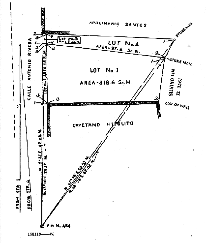
On the other hand, the respondent claims that the boundary line between his land and that of the applicant should begin at the point marked 2, which is the southeast corner of lot No. 4, and extend in straight line to point No. 3, which is the southwest corner of lot No. 4, and thence to the point marked 1, which is the southwest corner of lot No. 3 and is a point on the line of the street just named. The land in dispute is somewhat rectangular in shape, although the opposite lines are not parallel to each other. Its northern boundary line begins at the point marked 2 on Antonio Rivera Street, which is the northwest corner of lot No. 3, and runs, in accordance with the plan attached to the record and which accompanies this opinion, in an easterly, or slightly southeasterly, direction to the point marked No. 1, which is the northeast corner of lot No. 4 The boundary line then runs in a southwesterly direction to point 2, which is the southeast corner of lot No. 4; thence in a westerly or northwesterly direction to the point marked 1 on Antonio Rivera Street, which is the southwest corner of lot No. 3; and from this point it proceeds along the said street to the point of beginning.
The trial court found that the northeast corner of applicant's land was located, as claimed by the applicant, at point No. 1 of lot No. 4, which is the northeast corner of said lot No. 4, instead of being located, as claimed by the respondent, at point No. 2 of lot No. 4, which is the southeast corner of said lot No. 4. In other words, as to the point from which the description of applicant's land begins on the northeast, the land court found in favor of the applicant, disallowing the claim of the respondent that the point of departure should be point No. 2 of lot No. 4. The court, however, found in favor of the respondent with respect to the location of the extreme western point of his southern line, locating it at the point marked No. 1 of lot No. 3, which is the southeast corner of said lot, instead of locating it, as applicant prayed, at point No. 2 of lot No. 3, which is the northwest corner of said lot No. 3. In other words, the Court of Land Registration in its decision marking the boundary line between the lands of the litigants began at the rear of the lot at the point claimed by the applicant and from there drew a line to point No. 1 of lot No. 3, the southwest corner of that lot, the point claimed by respondent, thus dividing equally, or nearly so, the land in dispute between the parties. In other words, the court held with the applicant as to the location of the northeast corner of his lands, and with the respondent as to the location of the northwest corner. Thus, the land in dispute is somewhat rectangular and the division made by the Court of Land Registration divided this rectangle into two parts by a line drawn from the northeast to the southwest corner, giving to the respondent that portion of the disputed land which formed a triangle with its base on Antonio Rivera Street and its apex at point No. 1 of lot No. 4; and to the applicant the triangle whose apex rested on Antonio Rivera Street at point No. 1 of lot No. 3 and whose base was the line 1-2 of lot No. 4.
The court found as a fact that, at the survey, or partial survey, of the land made in case No. 7075 of that court, which involved the necessity of locating what in the plan in the case at bar is point No. 1 of lot No. 4, the mother of the respondent in this case, who was then the owner of the adjoining land now owned by the respondent, personally appeared and pointed out as the southeastern corner of her land, which would be the southeast corner of applicant's lot, a stone monument which is point No. 1 of lot No. 4. From that designation the plans in case No. 7075 were drawn and the boundary of respondent's land on the south was to that extent fixed. In the case at bar, however, the respondent has changed the positions of the southeast corner of his land as it was located by his mother, Apolinaria Santos, in case No. 7075, and has placed it at the point marked 2 in lot No. 4 of the plan filed in this case instead of at point 1 of said lot. From this it is clear that the respondent is seeking to obtain from the applicant a strip of land which was not claimed by respondent's mother at the time her boundary line was in dispute in case No. 7075. It should be noted that point No. 1 of lot No. 4 which was located by Apolinaria Santos as the southeast corner of her land was the same point designated by the applicant as the northeast point of her land and is the point from which, as she claims, the division line between her land and the land of the respondent should start.
Therefore, in the first controversy, namely, as to the northeast and southeast corners of applicant's and respondent's lands, respectively, we find the petitioner to be correct and the respondent to be wrong.
The next controversy was resolved by the Court of Land Registration in favor of respondent. It related to the location of the point on Antonio Rivera Street at which the line drawn from point 1 of lot No. 4 should touch — whether it should be located at point No. 1 or point No. 2 of lot No. 3. Over the location of that point there raged the same controversy that arose with regard to point No. 1 of lot No. 4, which, as we have seen, was the point of departure from the rear of the lot. To settle that controversy the land court again referred to case No. 7075, in which it appears that the frontage of applicant's land on Antonio Rivera Street was set down as 13.78 meters, which is substantially the length of the line 1-2 of lot No. 3. The court states, however, that, at the time that line was located in case No. 7075, neither the applicant in this case nor anyone representing her was present; and that he in no way gave his consent to the street frontage set out in case No. 7075. The court also states that the points between which the street line measuring 13.78 meters was drawn in case 7075 were pointed out and named by the same Apolinaria Santos who located point No. 1 of lot No. 4. The court calls attention, however, to the fact that in his declaration for taxation made in 1901 by the applicant's father in this case he describes his land as fronting on the street a distance of 13.65 meters, which, as the court, observes, closely approaches the measurement made in case No. 7075 in which the street frontage was fixed at 13.78 meters.
It appears from the evidence in the case that Apolinaria Santos, the mother of the respondent and the person from whom he derives his title, was present, as we have already stated, when the survey was made for the plan in case No. 7075. She was also present when the survey of the land in this case was made, and was on the ground at the time the land court made a personal inspection thereof for the purpose of determining thereby the actual location of the boundary line between the lands of the contending parties in this case. She was one of the prominent figures as she was one of the principal witnesses in this case. With respect to her testimony the land court said:
It is said that the court should be under the necessity of saying that it is unable to give any credit to the testimony of Apolinaria Santos, and if it were not for her advanced age she ought to be prosecuted for perjury. She denied roundly that she was present at any one of the surveys of the land in question but the court is convinced that she was present and pointed out the boundaries of the land during both surveys; and having testified falsely with regard to that matter, her declaration is of very little value.
Nevertheless, the court accepts her testimony with respect to the location of a certain stone alleged to have been found by her at point No. 3 of lot No. 4, which marked, as she claimed, the boundary line between her land and that of the applicant. The court, in accepting her testimony, says that "her declaration is corroborated by other witnesses with respect to certain points, especially with regard to the existence of a stone that is located approximately at point 3 of lot 4 in the plan Exhibit A in this case, which, according to her (Apolinaria Santos) marks the division line between her land and the land in question with respect to that portion thereof which fronts on the street. The existence of such a stone is proved by the testimony of the survey Mr. Beattie, and although said stone was not pointed out to the court during its inspection of the premises, nevertheless, it has no doubt that such a stone exists."
With respect to the stone marking the boundary line between the lands of the parties on the west, that is, on the street, referred to in the quotation just made, it appears that the applicant, by means of competent and qualified witnesses, duly identified the land described in the petition, and the whole thereof, as her land which had been occupied by her and her predecessors in interest for many years. To meet this testimony Apolinaria Santos, the former owner of the land on the north, took the stand as a witness for the respondent and declared that lots 3 and 4 had always been a part of her land and that her home was partially built thereon, and that the true boundary line between her land and the land of the applicant be so drawn as to include lots 3 and 4. She claimed that her house was erected more than ten years before the trial and that all parts thereof, including the kitchen, were constructed at the same time. In view of this conflicting testimony the court determined, as we have already seen, to make an ocular inspection of the premises; and, proceeding to the scene of the controversy, found that no part of the respondent's house was located on lots 3 and 4 now claimed by him save a projecting kitchen which was probably built sometime after the construction of the house itself. It should be noted that while the court was present on the land and engaged in the attempt to locate the boundary line between the lands of the parties, and especially where the lands touched the street neither the respondent nor his mother made any effort to point out a monument, stone or other sign that would indicate a boundary line or corner on the street. The only stone or monument point out by Apolinaria Santos was a stone imbedded in the earth at the precise spot claimed by the applicant as marking the corner of her land. After the court had withdrawn from the land, however, and resumed the session in the court room, Apolinario Santos then offered herself as a witness and proceeded to testify that the ocular inspection, which applicant claims marks the true corner, had been place there by her not as indicating the corner of petitioner's land but as a protection for a Chinese tienda which was located at that corner; and it was then that she, for the first time, testified concerning the existence and presence of a certain stone located somewhere near point No. 4 of lot No. 1 as shown on the plan attached hereto, and claimed that this was a monument or boundary line between her land and that of the applicant. It is true, as the court says, that the surveyor, Beattie, vouches for the presence of some such stone, but it is to be observed that he does not mark or note that stone on his plan of the land, and he was, of course, not in a position to testify whether it was a boundary mark or not. As we have already stated, the stone in question was not pointed out to the court while he was on the ground and we do not know what his opinion with respect thereto would have been if he had examined it and the locality carefully. Moreover, as touching the value of the testimony of Apolinaria Santos, it should be observed that when she was confronted with the conflict between her testimony as to the southeastern corner of her land as given in 1910 and that given on the trial of this case, she promptly denied that she was present at the 1910 survey. This, as we have already seen, the court found to be false.
Summing up the grounds on which the court finds for respondent, it says:
The only part of respondent's house which is inside of lot 4 is the kitchen, and although the court is satisfied from a personal inspection that the kitchen was built sometime after the principal part of the house, the court is unable to say that the kitchen has not stood on the land for at least 10 years; and considering this fact, along with the other facts set forth, and particularly the fact that the petitioner's land in Exhibit H of case No. 7075 coincides exactly in that part which abuts on the street with line 1-2 of lot 2 of the plan Exhibit A in this case, and the fact that Ildefonso Tambunting, the father of the petitioner, stated in his declaration for taxation that the length of the street line was 13.65 meters, the court is satisfied that the point of division between the land of the petitioner and that of the respondent Apolinaria Santos, with respect to the part fronting on the street is point 1 of lot 3, and that the division line between the lands of the petitioner and respondent is a straight line between said point 1 of lot 3 and point 1 of lot 4 on the plan Exhibit A.
We thus have four grounds on which the court bases its decision in favor of the respondent:
1. The fact that there is a stone near the point which he locates as the place where the lands border on the street.
2. The fact that the surveyor himself testified that a stone is located at or near that point.
3. That the father of the present petitioner in declaring his land for taxation some years ago stated that his frontage on the street was about 13.65 meters.
4. That the kitchen of respondent's house stands partly on lot 4.
As to the first and second grounds, it appears to us that they have little force. While the testimony of Apolinaria Santos is corroborated by the surveyor Beattie as to the fact that a stone was located at or near the point claimed it is not corroborated with respect to the claim that said stone marks the boundary line. On that subject Beattie did not and could not testify; and the fact is that, in the plan which he made of the land in question, he nowhere marked that stone as a corner. We, then, have simply the uncorroborated testimony of Apolinaria Santos that such a stone in fact marked a boundary point. The trial court, as we have already seen, declared that her uncorroborated testimony was without any value whatever.
As to the third ground, we find on investigation and deliberation that it is not of importance to be influential in the resolution of the case. It is well known that no attempt is usually made in filing declarations for taxation to be accurate as to the boundaries of the land declared or of the precise length of the various lines inclosing it; and, while in the declaration referred to, an attempt seems to have been made to fix the precise length of the street line, it seems to have been taken from some old description (the declaration for taxation was made in 1901) which may or may not have exact. Moreover, the difference between the street frontage as set out by Ildefonso Tambunting in his declaration for taxation made in 1901 differs by only 2 ½ meters from that which is now claimed as the correct frontage. In addition, in 1901 no survey had been made of the property in question respecting the street frontage or any other portion of the land for that matter.
With respect to this same ground should also be noted that, even though the court accepted the stone in question as a boundary point between the lands of the contending parties, the decision does not follow that finding. The stone referred to was located by the court and by the respondent's mother at or very near point 3 of lot 4 and was said and claimed to be on the dividing line between the two estates. The judgment of the court, however, runs the boundary from point 1 of lot 3 to point 1 of lot 4, thus leaving the alleged boundary stone or monument well inside of the applicant's property. In other words, the boundary from point 1 of lot 3 to point 1 of lot 4 does not and cannot be made to pass through point 3 of lot 4. Therefore, if the stone in question is the boundary mark, the decision does not place the boundary line where it belongs. If the stone is not the boundary mark then there is no ground on which the decision holding it to be a boundary mark can be founded.
As to the fourth ground on which the decision is based, namely, that a part of the kitchen stands on lot 4, we may say that there is scant evidence on which such a finding could be made. As matter of fact, title by prescription has not been clearly presented as an issue. Moreover, while it is true that the respondent testified that the house and kitchen were built at the same time, i. e., in the year 1900, the court, nevertheless, found that the kitchen was built after the erection of the main part of the house, and, consequently, must have been built later than the year 1900. We find it stated in the testimony of the respondent and his mother that the kitchen has been located on lot 4 for at least ten years. This action was commenced in October, 1913, and, in order to have been located on the land in question for a period of ten years, the kitchen must have been built on or before the month of October, 1903. We find no other evidence in the record for the respondent as to when the kitchen was built except that of himself and his mother. Their evidence is contradicted by the testimony of witnesses for the applicant and on that evidence the court found that the kitchen was not built at the same time that the main part of the house was erected. We find no evidence apart from that already mentioned which shows that the kitchen was built between 1900 and 1903. Possession for 10 years not having been established, the claim of prescription falls.
We are satisfied on the whole case as it is presented by the record that the judgment should be reversed and that the title to the land described in the application should be registered in the name of the applicant.
The decree of the Court of Land Registration is hereby reversed and the cause returned with instructions to register title to the land described in the application in the name of the applicant. Without costs in this instance. So ordered.
Arellano, C.J., Torres, Johnson, Carson, Trent and Araullo, JJ., concur.
The Lawphil Project - Arellano Law Foundation


